NZ Coastguard Air Patrols select PC navigation package
New Zealand Coastguard’s Air Patrols have adopted the Memory-Map GPS mapping software package loaded onto a tablet PC for their primery navigation.
PRESS RELEASE
June 2011
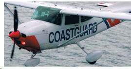
Coastguard is New Zealand’s primary marine search and rescue service provider. As part of this rescue service, the ten Coastguard Air Patrols cover the entire coastline. Operating as far as ten miles offshore, the Coastguard Air Patrol plays an integral role in supporting the Coastguard’s primary task of saving lives at sea. Occasionally, they’re also called in to assist with land searches in the bush and mountain regions.
Memory-Map QuickCharts software is designed for recreational use, but its ease of use has seen all ten Coastguard Air Patrols either using Memory-Map or committing to doing so.
The software is aimed primarily at boaties, hunters and trampers in New Zealand and other parts of the world including Australia, the Americas and Europe. Its maps look like paper maps, scroll fast and can be loaded onto PCs, iPhones/iPads, handheld GPS’s and other mobile navigation devices.
The Coastguard Auckland Air Patrol runs Memory-Map QuickCharts on a Hewlett Packard tablet PC with stylus touch screen and SSD memory, after standard devices were found to be unsuitable in the often bumpy environment.
“The low space needed, along with the computing power available, is far superior to using a typical marine chart plotter for the task. In addition, the fiscal benefits of merely upgrading the software in future instead of replacing a complete plotter will be most welcome,” says Neil Harris, a volunteer and in-flight controller with Coastguard Auckland’s Air Patrol, who undertook the plotter replacement project.
In-flight controllers handle navigation and act as mission commanders during operations.
The adoption of Memory-Map QuickCharts came about when the marine chart plotting system they had been using neared the end of its useful life. “We had to find a replacement,” says Neil. “I evaluated the current range of marine plotters available. Most are large devices, which can be problematic in the small confines of a plane.”
Frustrated by this, Neil started looking at computer-based software. “I looked at many options. Some of the more expensive ones didn’t fly that well. They worked at boat speeds, but had difficulty tracking our position when we were flying. We also needed an option that was simple to use, as we have a great variety of volunteers who need to be able to use the software.”
Two of the air patrols, Auckland and Northland, own their own fixed-wing aircraft. The eight other air patrols around New Zealand use planes supplied by local flying clubs, supportive businesses and private owners who are on standby. In these cases, having the necessary navigational equipment in a portable grab-bag is crucial.
Steve Holder, Training and Technical Officer of the Coastguard Hawke’s Bay Air Patrol, says everything is portable – marine radio, battery box, switch gear and tablet PC.
Steve was part of the team that tested the navigation software. “Neil Harris and I were trying a number of different programs. I trialled Memory-Map QuickCharts and found it really good. Straight out of the box, it does 90% of what we want.”
The Coastguard Air Patrols use three types of map – marine, topographic and aeronautical – on the Memory-Map program. The software makes it possible to instantly switch between maps.
“Memory-Map gets us to the place we need to go and lets us mark the location. It also builds an exportable track log of where we’ve been, which is always needed for our records,” says Steve.
Neil Harris concurs. “Up in the air we need to know where we are in relation to the ground. Memory-Map is now the primary tool we use for navigation and search. Our GPS position is shown on the chart. We can drop a mark and select Go To and the program tells us the bearing, time to destination… everything.”
But the most appealing thing about Memory-Map is that the maps look exactly like familiar paper maps. They scroll and switch between scales instantly.
“What I like is that Memory-Map uses raster charts which reduce the possibility of operator error by hiding information layers. We can blow them up, and all the info is there. We can instantly pull up remote areas, for instance we could be up at Little Barrier and with a few touches of the stylus we get an instant map image of where our next task is located, such as the other side of the island, at Raglan or wherever. Modern plotters can do this too, but Memory-Map does it so much better for us,” says Neil. “It’s just superb. I’ve found nothing that comes close to it.”
He says that people in trouble often don’t know exactly where they are. It is the job of the Coastguard Air Patrol to spot them, assess how urgently they need help, especially at times when more than one distress signal needs to be attended to and relay their position to the Coastguard controller and rescue vessels.
“For instance, in one case I attended, a boatie who had broken down gave Coastguard Radio his position, but when we flew over the location we saw that there was no such vessel in the area. Comms asked him again, and he gave the same position as before. Comms then asked him to do a depth sounding. When he told them he was in 19 metres of water, we flew along the 20m depth line until we spotted him, many miles from where he thought he was. The whole process took less than an hour.”
Memory-Map QuickCharts is available on DVD from most chandlery stores with a RRP of $229.00. The software and charts can also be downloaded from the Digital Map Store for use on an iPhone or iPad.
For more information see www.memory-map.co.nz
Memory-Map was founded in the USA in 2000 with a mission to provide advanced navigation and map display software to the marine and outdoor recreation community. Since then the Memory-Map product line has grown to include product sets for seven different countries, coming to New Zealand shores in 2005. The NZ line up already features a strong DVD product set tailored for tramping, boating and other outdoor recreation activities. Recognising the growing demand for maps to be delivered directly to mobile devices, Memory-Map developed the advanced technology behind the Digital Map Store. This provides a secure channel for traditional map publishers to compete at the forefront of technology.